A Hiking Guide to the Neusiok Trail: Maps, Trail Sections and Conditions
The Neusiok Trail runs 20.4 miles across Croatan National Forest, from the Neuse River south to the Newport River, and forms Segment 16 of the Mountains-to-Sea Trail. This Neusiok Trail guide covers the three trail sections, where the boardwalks and shelters actually sit, which creeks still hold water in a dry autumn, and the seasonal window worth planning around.
It also carries the wider Croatan and Uwharrie National Forest material this site has long collected — trail maps and GPX files, campground notes, and the hammock-camping gear discussion.
01 — Section by sectionHiking the Neusiok Trail: the three sections, mile by mile
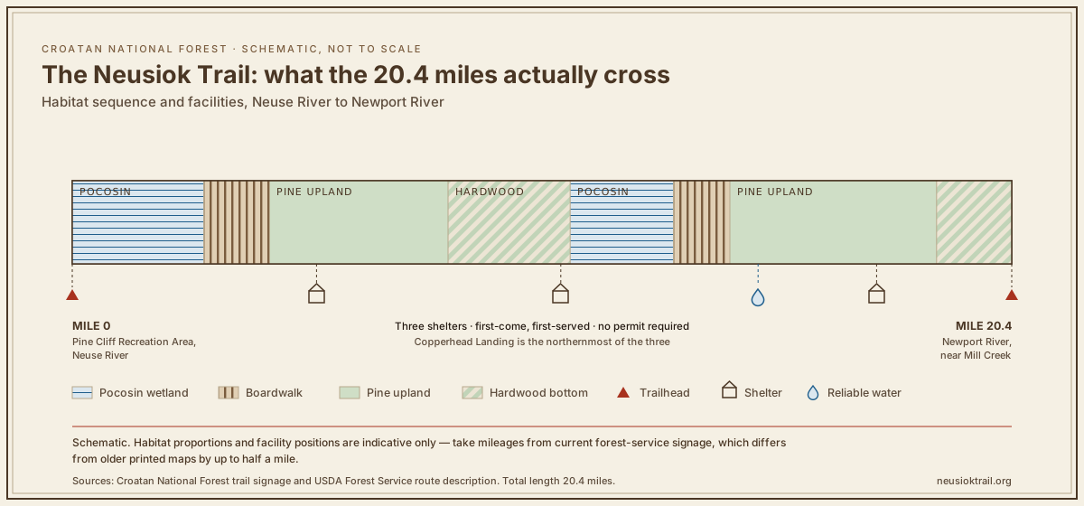
The Neusiok is not one habitat repeated for twenty miles. It alternates between pocosin — flooded evergreen shrub bog — and dry pine and hardwood upland, and the transitions are abrupt enough to notice underfoot within a few paces. The band below plots that sequence against the mile axis, with the shelters, boardwalks and reliable water marked.

North: Pine Cliff to Copperhead Landing
The northern trailhead sits at Pine Cliff Recreation Area, a day-use area on the Neuse and the conventional place to start a southbound walk.
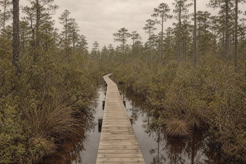
The northern miles leave the Neuse River and drop almost immediately into pocosin. This is the wettest stretch of the whole trail and the reason the boardwalk sections exist at all — without them the tread stays ankle-deep for weeks after heavy rain. Copperhead Landing shelter closes the section where the pocosin finally gives way to firmer ground.
Middle: the upland miles
Drier walking through longleaf and loblolly pine, with tread firm enough to make real time on. What little elevation change the trail has sits here, and so does the second shelter. If you are hiking the Neusiok Trail as three day-walks rather than end to end, this is the section that rewards an early start.
South: hardwood bottom to the Newport River
A final swing back through pocosin and hardwood bottom before the southern terminus near Mill Creek. The last miles are flat and, in wet months, slow.
Field noteMileages on the kiosk boards and on older printed maps disagree by up to half a mile. The figures used across these trail sections follow the current forest-service signage.
02 — Seasonal windowWhen to hike, and when the Croatan turns genuinely unpleasant
Summer here is not merely hot. It is humid coastal-plain heat with a biting-insect load that turns a pleasant twenty-mile walk into an endurance problem, and the pocosin holds standing water long after the uplands have dried out. The practical window for hiking the Neusiok Trail is late autumn through early spring.
| Factor | Jan | Feb | Mar | Apr | May | Jun | Jul | Aug | Sep | Oct | Nov | Dec |
|---|---|---|---|---|---|---|---|---|---|---|---|---|
| Heat & humidity | Jan: good | Feb: good | Mar: good | Apr: fair | May: poor | Jun: avoid | Jul: avoid | Aug: avoid | Sep: poor | Oct: fair | Nov: good | Dec: good |
| Biting insects | Jan: good | Feb: good | Mar: fair | Apr: poor | May: avoid | Jun: avoid | Jul: avoid | Aug: avoid | Sep: poor | Oct: fair | Nov: good | Dec: good |
| Standing water | Jan: poor | Feb: poor | Mar: poor | Apr: fair | May: fair | Jun: fair | Jul: poor | Aug: poor | Sep: avoid | Oct: fair | Nov: fair | Dec: poor |
| Hunting season | Jan: poor | Feb: fair | Mar: good | Apr: fair | May: good | Jun: good | Jul: good | Aug: good | Sep: fair | Oct: poor | Nov: avoid | Dec: avoid |
The two clean months are November and March — cool, low insect pressure, and either side of the heaviest hunting weeks. February walks well too, provided the preceding fortnight has been dry. Anyone planning a summer attempt should treat deerflies and ticks as the limiting factor rather than the temperature.
03 — Water & sheltersShelters, water, and where the trail gets hard
Three trail shelters sit roughly a third apart, which makes a two-night walk the natural rhythm rather than a forced march. Copperhead Landing is the best known of them and the one most often used as a first night.
Water is the real planning constraint. The pocosin holds plenty of it, but it is tannin-stained and slow to push through a filter; the upland creeks run clearer and drop first in a dry spell. Plan capacity for the full upland stretch rather than counting on a refill mid-section.
CautionThe tannin-black water of the Croatan will clog a fine filter quickly. A pre-filter or a settling bottle saves a cartridge.
04 — Maps & navigationMaps and GPX files for the trail
The trail is blazed and, in the upland sections, easy to follow. The pocosin stretches are where a map earns its keep: the tread braids around standing water and the blazes can sit further apart than is comfortable. A downloadable Neusiok Trail map and a GPX track for each section are collected on the maps page, together with the Croatan National Forest sheets.
Kiosk boards stand at the trailheads and at several road crossings. They are useful for orientation but, as the field note above records, their mileages are not always current — treat the printed map as the authority and the boards as confirmation.
05 — Beyond the NeusiokBeyond the trail: what else this guide covers
The rest of this Neusiok Trail guide reaches past the trail itself, because the material collected here never stopped at one route. The Croatan pages cover camping and trails across the forest, the Weetock Trail, and the hunting calendar that shapes when the forest is comfortable to walk. Inland, the Uwharrie National Forest map collection covers the Uwharrie National Recreation Trail, Badin Lake and Dutchman's Creek — the most-consulted material collected here.
The hammock-camping and gear sections carry the long-running discussion of bridge hammocks, bug nets, insulation and gravity filters that grew up around this trail and the people who walk it. What that came down to in practice is collected in the hammock camping notes: bridge versus gathered-end, bug nets, and insulation for cold coastal nights.
06 — QuestionsCommon questions about hiking the Neusiok Trail
How long does it take to walk end to end?
Most walkers take two to three days for the full 20.4 miles, using the three shelters as stopping points. Fit hikers finish it in a single long day, though the pocosin sections slow a pace far more than the mileage suggests.
Where can I get a trail map?
A downloadable Neusiok Trail map and per-section GPX files are collected on the maps page, alongside the Croatan National Forest sheets and the Uwharrie set.
Is there water along the route?
Yes, but unevenly. The pocosin holds tannin-stained water that filters slowly, while the upland creeks run clearer and dry out first in a rainless autumn. Carrying through the long upland stretch is the safe assumption.
When is the best time of year to walk it?
Late autumn through early spring. November and March are the two cleanest months — cool, low insect pressure, and either side of the heaviest hunting weeks.
Are the shelters first-come, or do they need booking?
All three are first-come, first-served. No permit or reservation is required for backcountry camping in Croatan National Forest, which is part of why the trail suits a spontaneous weekend.
Can the trail be walked in shorter sections?
Yes — the mid-trail road crossings split it into three practical day-hikes, so a shuttle is only needed for an end-to-end walk.